 Deutsch
 Ελληνικά
 English
 Italiano
 Türkçe
 汉语
汉语


Driving SH95 from Manapouri to Te Anau | Southland | New Zealand | 4K
2,393 views
Categories: Southland Region
Added: 3 years ago
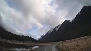
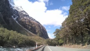
Driving SH95 from Manapouri to Te Anau, in the Southland region, on the South Coast of New Zealand's South Island.
Manapouri is located at the edge of the Fiordland National Park on the shores of Lake Manapouri. The lake is the second deepest in New Zealand at 444 metres, with a circumference of 170km. The town provides a good base for trips into the glacier-carved wilderness of Fiordland National Park. It also has a good range of accommodation and a small number of shops and eateries.
Manapouri was originally called Roto-au (the rainy lake) by early Maori, and then Moturau (many islands). The town is the departure point for Doubtful Sound trips and excursions to the West Arm Power Station, the largest underground power generation in the southern hemisphere. Kayaking on the lake is weather dependent but an excellent way to experience the remote bays and sandy beaches. Many hiking trails in the area include the Circle Track, Kepler Track, and the remote Dusky Track.
Te Anau is an attractive resort town and holiday destination. The picturesque village is situated on the shores of the second-largest lake in New Zealand and the South Island's largest lake - Lake Te Anau.
The lake has three large fiords, North Fiord, Middle Fiord, and South Fiord. These are the only inland fiords in New Zealand, with most of the lake within the Fiordland National Park. Its quiet deep waters are bordered by lush native forest, rolling hill country, and the scenic Kepler and Murchison mountain ranges. This makes the lake a scenic playground for adventure activities like jet boating, water skiing, kayaking, swimming, fishing, boating, and paddling. The western shore of the lake also features the Te Anau Glowworm Caves
Comments (0)
Show Comments
-
Driving from Te Anau to Te Anau Downs - Road trip along SH94 | Southland | New Zealand | 4K 1698 views
 07:49
07:49
-
Driving Hillside Manapouri Road from Lake Manapouri to SH94 | Southland | New Zealand | 4K 1913 views
 11:33
11:33
-
Driving from Te Anau to Henry Creek DOC Campsite along SH94 | Southland | New Zealand | 4K 1825 views
 06:01
06:01
-
Driving from Whare Creek to Manapouri | Southland | New Zealand | 4K 1756 views
 12:08
12:08
-
Old Caterpillar Diesel Crawler Tractor on display at the Fiordland Vintage Machinery Museum | 4K 2224 views
 01:08
01:08
-
Driving from Te Anau Downs to Eglinton Valley - Road trip along SH94 | Southland | New Zealand | 4K 2313 views
 05:26
05:26
-
Driving around Knobs Flat in the Fiordland National Park | Southland | New Zealand | 4K 2477 views
 01:09
01:09
-
Driving from Eglinton Valley to Knobs Flat - Road trip along SH94 | Southland | New Zealand | 4K 2288 views
 03:05
03:05
-
Driving from Eglinton Valley to the Mirror Lakes Car Park along SH94 | Southland | New Zealand | 4K 2484 views
 01:21
01:21
-
Driving from Homer Tunnel to Christie Falls in Fiordland 2280 views
 03:54
03:54
-
Driving from Knobs Flat to Lake Gunn Carpark in Fiordland 2263 views
 03:31
03:31
-
Driving from Christie Falls to Milford Sound in Fiordland 2586 views
 10:47
10:47

© ScenicDrive Productions 2026